We are finally through and beyond the Kyzyl Kum desert. If it’s felt like you’ve been reading about our desert crossings for a while, I can safely say that cycling them will have felt longer. 1600km ended up being about 120 hours on the saddle within two weeks, grim stats which are made to look more bearable thanks to a quick final passage out of Uzbekistan. Completing this challenge was a big physical thrill, but it was also an amazing feeling to ride into the oasis towns of Khiva and Bukhara having retraced the steps of so many Silk Road caravans before us – and probably sharing their feelings of exhausted elation. We are now resting up in the Tajik capital of Dushanbe preparing ourselves for the next challenge of the expedition, which will surely eclipse any hardship we ever felt in Uzbekistan. Desert has been replaced by mountains. These stand between us and the Chinese border, and will need to be crossed if we are going to make it to Hong Kong.
The mountain range we plan to cross is called the Pamir. This was the setting of the Great Game in the 19th century, the world’s first cold war between Great Britain and the Russian empire, as each country tried to carve out spheres of influence in Central Asia. British-led expeditions expanded north from India and the Russians moved south from the motherland, meeting awkwardly in the middle above Afghanistan: in the Pamirs. It was high in these snowy mountains that the British played a dangerous game of hide-and-seek with the Russians, and through them that they eventually succeeded in marching on Lhasa, Tibet in 1904. There are some spy stories from that era which are little known – epic is an understatement.
One of the routes which the British and the Russians mapped out in the 19th century has since become the Pamir Highway, linking Tajikistan to Kyrgyzstan to China across dizzyingly high mountain passes. It is the second highest highway in the world (after the Karakorum Highway just to the south), the ‘roof of the world’ which joins up with the Tibetan plateau further east. The Chinese have built more direct roads to their border so haven’t yet bothered paving the Pamir Highway: much of it therefore remains dirt track, subject to rock slides in the summer and avalanches in the winter which can effectively close it for weeks. Because of the area’s remoteness, the lifestyle of the Pamiri people who live up there hasn’t changed much in a century. For us there will be no food nor water available for days on end and we will be relying on a satellite phone to check in with people back home when we can. The Highway plateau is at a height of 3500m and the mountain passes we have to cross climb up beyond 4000m. Here lack of oxygen and altitude sickness will both be new challenges. Being so high and surrounded by mountains, the weather can be very harsh too: water freezes overnight in July and powerful winds can literally knock you over. To top things off nicely, the British Embassy officially discourages travel in the region, partly due to the difficulty of staging would-be rescue missions if people get lost in the snow.
Most people who choose to visit the Pamirs do it from the inside of a comfortable 4WD, but there are still a number of die-hard cyclists who attempt to cross into China via the Pamir Highway during the summer months. Despite the challenging conditions, it is not hard to see the attraction: these 1500km of mountain road have been dubbed the adventure cycling ‘holy grail’ – the pinnacle of proper preparation and physical fitness – and the stunning views of the Pamir and Hindu Kush mountain ranges that you get on the plateau make the strenuous climbs well worth it.
We are going to attempt to cross the Pamirs during winter. By the time you read this blog we will already be up there. Not quite the conventional holiday period, but unfortunately we weren’t given much choice! Our expedition timings decided things for us: leaving London in July meant reaching the Tajik mountains in December, unless we wanted to wait out the winter somewhere more sunny and sensible. Both Tajiks and Uzbeks who asked us about our onward journey reacted in mixed ways when we told them where we were headed. The general consensus is that we’re crazy foreigners and have got the seasons horribly wrong. Otherwise reactions have ranged from polite incredulity (“you must be joking”) and being laughed off, to serious concern (“you will certainly die”). One Tajik man sat us down to list the reasons why he thought we wouldn’t emerge alive, from wolf attacks, to freezing to death, to Taliban raids.
It is true that wolves are quite regularly spotted up on the plateau, a great safari opportunity for summertime tourists from their 4WD but perhaps more of an issue for us on our exposed bicycles. In winter, finding food in the snow is difficult. So we have followed advice in Dushanbe and bought large knives (probably more comforting than useful) and also have a big pointed stick, the end of which we can set alight with a cloth soaked in petrol if we find trouble. Wolves are apparently only a serious concern if we find a pack of them, or if we are jumped by a hungry few at night. The Tajik man was certainly right about the cold: overnight temperatures up there are currently ranging from -30C on a good day to -40C on a grim one, at which point you can get frostbite reasonably quickly. The cold along with the potential fierce winds will be our two biggest challenges, having now had plenty of headwind experience crossing the Kyzyl Kum (that part wasn’t fun). As for the Taliban, they are quite low on our list of things to worry about. Our route runs along the Afghan border for some distance, which is heavily garrisoned as it’s the main drugs conduit into Europe. The military probably aren’t there to stop the drugs, but rather to control their passage for a fee. There have been Taliban raids on border posts on the Afghan side, but the Taliban have not yet once crossed the river to the Tajik side. If they do we have our trusted pointed stick as previously mentioned.
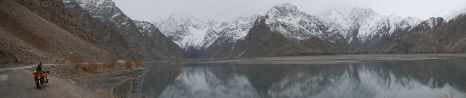
Our route outline

The Pamir Highway from Dushanbe to Khorog, Murghab and Kashgar
Here is a very brief outline of our route. It should take us about a month to reach the Chinese border from Dushanbe, a route which can be split very basically into three legs of increasing difficulty:
Dushanbe to Khorog – The Approach: 10 days, 600km
The Pamir Highway doesn’t technically close for winter, but there is enough snow on parts of it to make some sections impassable. By the time we arrived in Dushanbe it had already snowed heavily on the first leg of the Highway, the road now covered with about a foot of the stuff which effectively unofficially closed it. The road won’t be passable again until spring, but luckily there is another route which dips further south and remains open all winter: this is the one we’ll be taking.
This first section out of Dushanbe – The Approach – will be the most straightforward compared to the next two. The road is paved half of the way, there is still some traffic and there are villages to sleep in too. We will be below 2000m altitude until Khorog (2070m), so snow should not be a problem yet. What will make it difficult is the total ascent: we will start climbing straight out of the Tajik capital and do a series of ups and downs over small passes to get to Khorog, the capital and gateway of the Pamirs. Our southern route follows the Panj River along the border with Afghanistan until joining up with the Highway again a few days before Khorog. Although this is the main trucking route into China, the road is apparently narrow and rocky. In total we will pedal 11,000 vertical metres in about 10 days – to put it into perspective, Mount Everest is just under 9,000 metres high.
Khorog to Murghab: 10 days, 450km
Having cycled the Highway for a short stretch we then divert south from Khorog to the Wakhan Valley, where tarmac definitively stops to be replaced by bumpy dirt road. We will continue to follow the Panj River which contours the Afghan border before taking on our first serious mountain pass (4344m) where we will climb up to rejoin the Highway plateau. Here civilisation disappears to be replaced by heavy snow and wind until Murghab, which lies at 3630m. This will be the toughest test of the whole expedition for our bikes, as well as for our warm kit. Taliban watch followed by wolf watch – an excellent 10 days.
Murghab to Kashgar: 5-10 days, 550km
The hardest section of the Highway. To reach Kashgar we will have to strike north from Murghab towards Kyrgyzstan by crossing the Akbaital Pass at 4655m. There will be no settlements at all anymore except for a few abandoned huts, as the conditions in winter are too harsh for anyone to choose to stay up there. We will descend briefly from the pass before climbing another one (4336m) into Kyrgyzstan where the climate will get wetter and more unfriendly. We have no idea of when we’ll have a long enough weather window to then dash east for the Chinese border. It is possible to be delayed for days by blizzards in Sary Tash, the Kyrgyz outpost where we hope to spend Christmas (but not New Year!!). The likelihood is that we’ll be pushing the bikes at this stage as there will be too much snow on the ground to cycle.
Once through the Chinese border it is not possible to cycle all the way to Kashgar, because apparently the Chinese border guards view cyclists as a security threat. I don’t know what they’ll make of us two in winter then! Around this border is where most drugs cross into China from Afghanistan, so police there apparently lack a sense of humour. Our passports will be confiscated and we will probably be bundled into a lorry to be driven a long downhill stretch most of the way. After over 20,000m of total ascent it seems a bit cruel to be denied the epic freewheel down the other side. But by that stage we may be too tired to care.
So that’s what’s coming up! As always, thank you very much for your continuing support as we get towards the deep end of our expedition! It really is a huge morale boost as we take on these endless snowy mountain climbs and is a large part of what keeps us pedalling. If you’re thinking about making a Christmas donation to Prostate Cancer UK and supporting us up the Pamirs, please follow this link. Thanks again from both of us in wintry Tajikistan! X
Nick


Thanks SO much for your blog on the Dushanbe to Khorog or whatever leg! Amazing views and great descriptions, Nick. Hope you got a decent enough new wheel for the road conditions and load…
Can we get Real Money to you both for Christmas? So you can afford a break when you get the next chance! We’ll give more to The Cause too, mind.
Well done, and all our friends are avid followers of your blog!
Simon and Maddy xxx